SPOT 1 HIGH
ESE drop-off seam
Score79
Run from Alligator Reef11.4 NM
- Temperature break
- Chlorophyll front
- Eddy
Bottom: 239 ft, inside the 100 to 300 ft band
Center 24° 56.89′ N, 80° 23.83′ W
Report Guide Library · 1 of 5
Fish stack where two or more edges meet in the same water: a temperature break, a color line, a current edge, an eddy. One edge is a maybe. Three in the same place, at a depth you fish and a run you can make, is where you start.
The convergence map finds those places in every report and ranks the best three. This page walks through one real report: Alligator Reef, Friday, October 2, 2026. Its top spot scored 79, the highest of any Keys morning report from mid-September to mid-October 2026.
Where all three line up: spot 1, 11.4 NM off Alligator Reef, on 239 ft of bottom. Score 79, confidence HIGH.
Sea temperature: the water warms about 2 degrees moving offshore. A soft step, but a step, and spot 1 sits on it.
Water color: green inshore water meets clean blue. Bait holds on the line, and spot 1 sits on it.
Eddy: the ranking found an eddy edge running through the same water as the other two.
The map is drawn from that morning’s report and the satellite layers stored for that day. Switch the water underneath and watch spot 1 sit on the edge every time.
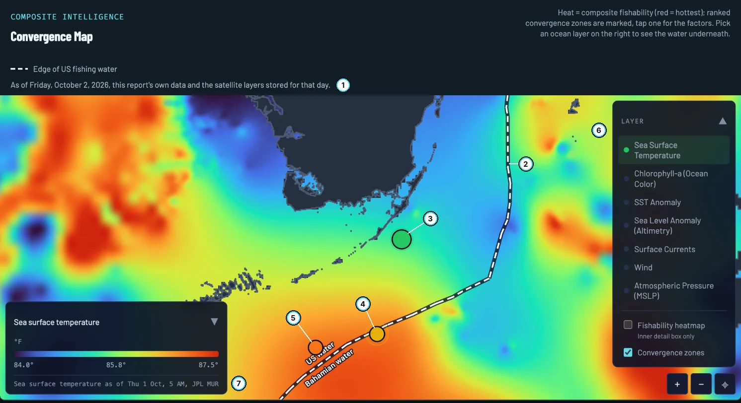
Tap a pin for its rank, position, score, confidence and the edges behind it.
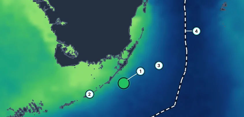
Temperature and color line up in the same place. That is the overlap the score rewards.
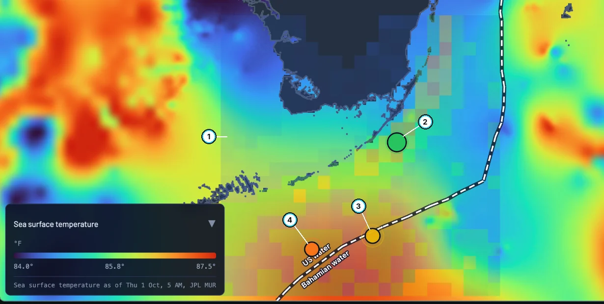
The reddest square is not automatically the top spot. The ranking also weighs depth and the run.
Each spot down the list on October 2 has fewer edges, deeper water or a longer run than the one above it.
Your call first: which one would you run?
Bottom: 239 ft, inside the 100 to 300 ft band
Center 24° 56.89′ N, 80° 23.83′ W
Bottom: Deeper than the band
In Bahamian water: Bahamas permits needed
Bottom: Deeper than the band
The longest run of the three
If you picked spot 1
Good call. Spot 1 wins on all three counts: three edges overlap there, including the temperature break and color front the others lack; it sits on the drop-off depth that holds bait off the Keys; and it is the shortest run.
If you picked spot 2
Close, but the report ranked it second. Spot 2 is a real water-mass edge, but it has no temperature or color break, it is deeper than the band, and it is nearly three times the run, across the line into Bahamian water.
If you picked spot 3
That one ranked last. Two edges, deep water and the longest run. A far spot has to be clearly better than a near one to outrank it. On this day none was.
Runs are straight lines from Alligator Reef, not routes. Spot 2 sits in Bahamian water and needs Bahamas permits; permits and bag limits can change, so confirm current regulations before you fish.
The ranking does the overlap for you, but look before you run. Three switches, about a minute.
STEP 1
On October 2 the water warms about 2 degrees moving offshore from the reef: a soft step, not a hard break. Spot 1 sits on it.
STEP 2
Green water along the Keys holds bait; blue water offshore is where pelagics travel. Spot 1 sits right on the line between them.
STEP 3
Turn on the heat. The reddest square is not automatically the top spot: the ranking also weighs depth and the run. Use heat for shape, the ranked spots for where to go.
WHERE
79 / 100
The best water of the season: spot 1, 11.4 NM out, three edges on 239 ft. Confidence HIGH.
WHETHER
Small Craft Advisory until 8 PM
East to southeast wind near 20 knots and a steep 3 to 4 ft chop. The report’s plan: run the 11.4 NM early, tuck back to the reef edge if it stood up, and expect the seas to lay down over the weekend.
The best water tells you where. The forecast tells you whether.
A place where two or more edges meet in the same water: a temperature break, a color line, a current edge or an eddy rim. Bait gathers where water masses meet, and the fish that feed on bait follow it.
Heat scores the water alone. The ranked spots also weigh whether that water sits in the depth band you fish and how far you have to run. Use the heat for the shape of the good water and the ranked spots for where to go.
Only when it is worth it. A far spot has to be clearly better than a near one to outrank it, and every spot shows its straight-line run in nautical miles so you can hold it against your boat and the day.
FishIntel covers US waters and the Bahamas, and every zone gets its own map and ranked spots in its report. The Florida Keys are calibrated; other regions are marked drafted until they are checked against their own water, and the report says which applies.
Report Guide Library
Pick your water and get a free report with its own convergence map and three ranked spots.
FishIntel is for information only. It is not for navigation or safety-of-life decisions.