Daily Fishing Intelligence
Alligator Reef, Friday, October 2, 2026
This is a real report, pulled from the production run the morning it was written. Subscribers get one like it for their own water every day.
Analysis by FishIntel, built by Captain Kit Carson, licensed charter captain, Islamorada, Florida Keys.
This is one FishIntel morning report for Alligator Reef, off Islamorada in the Florida Keys, shown in full. It reads the water around your zone from satellite and buoy data, then ranks where to fish and how each species looks that day.
How to read this report
- Conditions Summary is the morning in a paragraph. Start there.
- Convergence Zones lists the spots where the temperature, color and current edges stack up, best first.
- Report data, at the foot, tells you how old each layer is, so you know how much weight to give it.
For the full walk-through of the rating, the spots and the charts, see How to read your FishIntel report.
Start FreeMarine advisory in force
Small Craft Advisory
Straits of Florida from Ocean Reef to Craig Key out 20 NM; Straits of Florida from Craig Key to west end of Seven Mile Bridge out 20 NM; Straits of Florida from west end of Seven Mile Bridge to south of Halfmoon Shoal out 20 NM; Straits of Florida from Ocean Reef to Craig Key 20 to 60 NM out; Straits of Florida from Craig Key to west end of Seven Mile Bridge 20 to 60 NM out
until Fri 8:00 PM EDT
What it means today
East to southeast winds near 20 knots. Check the current marine forecast before deciding to head out.
As of Fri 5:05 AM EDT, from this report's check.
Flags are the traditional marine signals for each warning.
👁️ Captain's Eye on the Charts
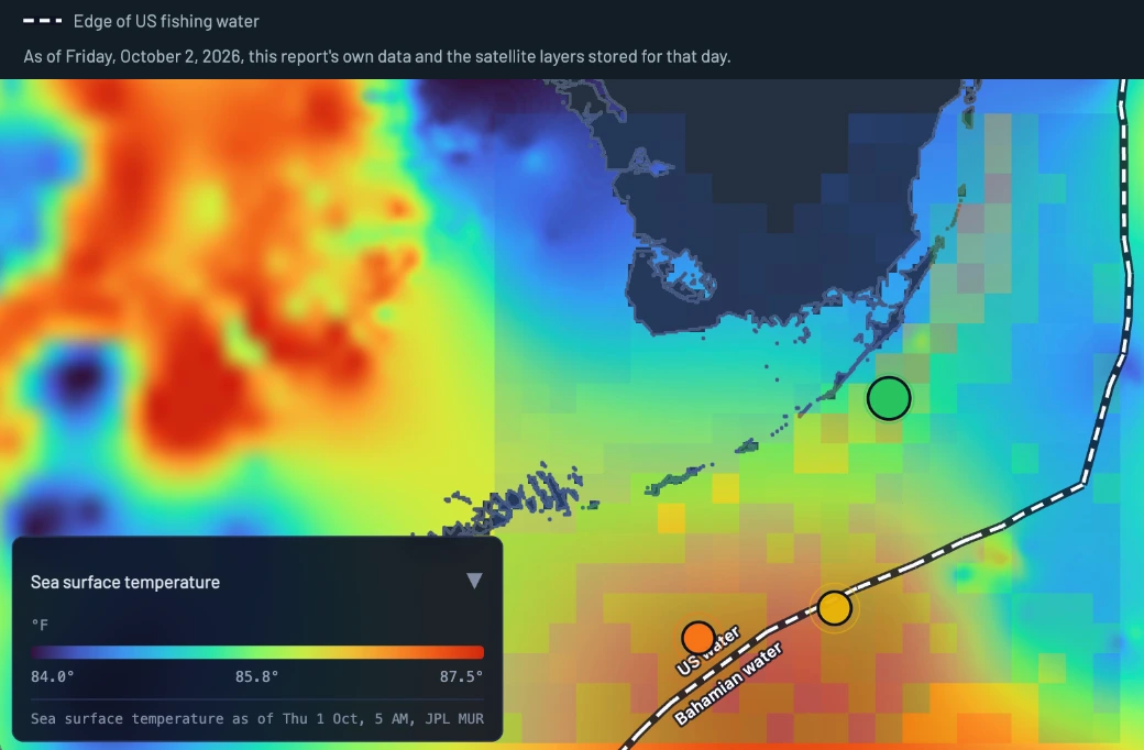
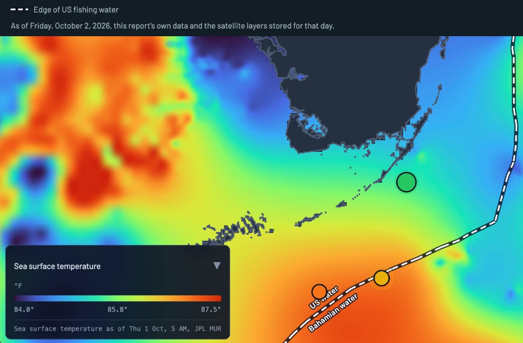
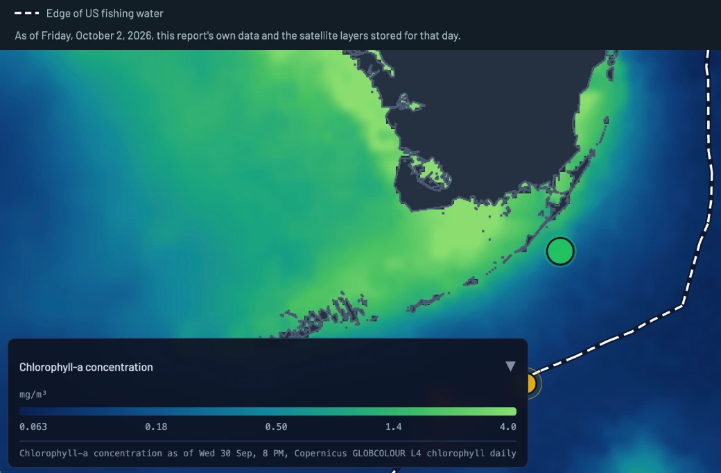
The temperature picture is soft but readable. Cool water fills Florida Bay and the Gulf side, and a cooler band hugs the outside of the Keys. Moving offshore from Alligator Reef, it warms steadily toward a warm tongue centered roughly 20 to 25 mi ESE,. That step runs NE to SW, parallel to the reef line. It is a gentle gradient, not a knife edge, and it tightens most about 5 to 10 mi outside the reef. The SE corner of the chart cools slightly again. Chlorophyll tells the clearest story. Dark, productive green stacks against the Keys, and the color line falls just a few miles outside the reef, tracking the same NE to SW trend. There is no true blue water in the frame. Offshore stays a paler, cleaner green, so the edge is a shade change rather than a hard rip. Sea level is positive everywhere. It runs higher on the Gulf side and lower toward the east, with the lowest values under that warm tongue. There is no closed eddy, and at this coarse grid the Stream core is not cleanly defined. These charts converge along a band 4 to 10 mi off Alligator, where the warming step and the color line overlap. That is the seam I'd troll first.
Conditions Summary
The best water today is the seam 11.4 NM from Alligator Reef where a soft 2 degree warming step, a green-to-cleaner color line and an eddy overlap right on 239 ft of bottom, square in the 100 to 300 ft drop-off band. That is zone 1, and it is the first place to put baits. The constraint is the breeze: a Small Craft Advisory runs until 8 PM for the Straits with east to southeast wind near 20 knots and a steep 3 to 4 ft chop at 5 seconds, so run early, tuck back to the reef edge if it stands up, and know the sea lays down to 1 to 2 ft by Sunday. This report covers the water within 50 nautical miles of your zone, so it reads where you fish as well as where you launch.
Sunrise 7:15 AM; sunset 7:08 PM (local time).
Convergence Zones
Distances are straight-line runs from Alligator Reef.
- Zone 1: ESE drop-off seam 11.4 NM from Alligator Reef Center: 24° 56.89' N, 80° 23.83' W
- Zone 2: South salinity-edge water 30.8 NM from Alligator Reef Center: 24° 23.29' N, 80° 33.43' W This spot is in Bahamian water. You need a Bahamas sport fishing permit, issued at a port of entry, and a cruising permit. Bag limits apply, and spear guns and scuba are not allowed for fishing. Paying for permits online in advance does not authorize entry or fishing. Complete entry in person at a Bahamian port of entry before you fish. Official rules: Bahamas Department of Marine Resources.
- Zone 3: Southwest eddy seam 40.5 NM from Alligator Reef Center: 24° 18.49' N, 80° 57.43' W
Zone 1
Zone 1: ESE drop-off seam.
A 11.4 NM run from Alligator Reef puts you on the only spot where three measured factors overlap, a temperature break, a chlorophyll front and an eddy, all sitting on 239 ft of water right in the 100 to 300 ft band. Confidence is HIGH, and the imagery read calls this same band the first seam to troll.
Zone 2
Zone 2: South salinity-edge water.
30.8 NM from Alligator Reef, this water pairs a current edge with an eddy and a salinity gradient, a real water-mass boundary even without a temperature or color break on it. Confidence is HIGH, but the bottom sits deeper than the 100 to 300 ft band, so it is the second look rather than the first.
Zone 3
Zone 3: Southwest eddy seam.
40.5 NM from Alligator Reef, this spot carries an eddy and the salinity gradient and nothing else, and confidence is LOW. It is deeper water and a long run for a thin stack of evidence, so it holds rank 3.
Upcoming Days
as of 5:05 AM local
Air temperatures: Open-Meteo forecast, °F.
Written with the report, October 2.
Saturday
Oct 3
FAIR: seas 3.1 ft, 3.1 ft at 4.5 s, period borrowed from model, steep chop, wind 13 kt peak (model)
E 13 kt peak (model); most hours 8-11 kt
NWS Key West 2 to 3 ft, 3 ft at 5 s; model day maximum 3.1 ft, 4.5 s max period
81°F
80°F
Sunday
Oct 4
GOOD: seas 2.6 ft, 2.6 ft at 4.1 s, period borrowed from model, wind 13 kt peak (model)
ESE 13 kt peak (model); most hours 9-12 kt
NWS Key West around 2 ft, 2 ft at 4 s; model day maximum 2.6 ft, 4.1 s max period
82°F
81°F
Monday
Oct 5
GOOD: seas 1 to 2 ft, 2 ft at 4 s, period assumed 4 s, wind SE 5-10 kt (NWS Key West); model EXCELLENT: seas 1.6 ft, wind 9 kt peak
SE 5-10 kt (NWS Key West); model SE 5-8 kt
NWS Key West 1 to 2 ft, 2 ft at 4 s; model day maximum 1.6 ft, 3.9 s max period
83°F
81°F
Tuesday
Oct 6
GOOD: seas around 1 ft, 1 ft at 4 s, period assumed 4 s, wind S 5-10 kt (NWS Key West); model EXCELLENT: seas 0.7 ft, wind 5 kt peak
S 5-10 kt (NWS Key West); model SE 3-5 kt
NWS Key West around 1 ft, 1 ft at 4 s; model day maximum 0.7 ft, 3.9 s max period
82°F
81°F
Wednesday
Oct 7
EXCELLENT: seas 0.7 ft, 0.7 ft at 4 s, period borrowed from model, wind 4 kt peak (model)
SSE 4 kt peak (model); most hours 3-4 kt
model day maximum 0.7 ft, 4 s max period
82°F
80°F
SST Analysis
Zone water averages 85.9 F and runs 83.8 to 87.0 F. That is a 2.4 degree climb across roughly 15 NM, a soft step rather than a knife edge, and the imagery read puts the tightest part of it 5 to 10 miles outside the reef line. A 2 degree step is enough to concentrate baitfish along the boundary, and gamefish ride the warm side of it. The computed break list is empty today, so treat the tongue edge itself as the feature. Takeaway: troll the warming step where the mid-84s climb toward the 87.0 tongue, working it northeast to southwest, and zone 1 sits right on that line.
Water Color & Chlorophyll
Coverage is thin this pass at 3 cells, values running 0.066 to 0.092 mg/m3 and averaging 0.081, all of it pale. The greenest cell on the grid is 0.092, run distance unavailable and about 1.2 NM outside your zone circle, with a 0.085 cell just inside the circle, 45.4 NM out. The cleanest reading, 0.066, sits farther east. Front strength is 0.026, weak, which matches the imagery: no true blue water in frame, just darker green stacked against the Keys fading to paler green offshore, with the color line a few miles outside the reef. Greener water holds the bait and the paler side is where you want your baits swimming. Takeaway: fish the shade change close to the reef, not a hard rip, and do not run offshore looking for blue water that is not there today.
Currents & the Gulf Stream
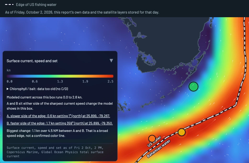
Measured flow inside the zone is gentle, a mean 0.85 knots setting NE at bearing 43. The muscle sits outside the circle: the strongest cells run 2.2 to 2.4 knots toward the NE, led by 2.36 knots, run distance unavailable and about 2.5 NM outside your zone circle, with a matching 2.33 knot cell setting ENE, 52.2 NM out. That axis is the Florida Current proper, and today it lies mostly beyond the 50 NM ring. Sea height tells the same soft story: a 0.43 ft step across the zone, from 0.40 ft up to 0.83 ft, 41.8 NM from the reef, a difference in sea height rather than a hard rip line. The charted shoreward edge of the Gulf Stream as of September 25 sat 4 NM south-southeast of Alligator Reef Light. Takeaway: with no ripping edge inside 20 NM, fish the temperature and color seams instead of hunting a current wall.
Salinity
Average salinity is 36.05 PSU across 37 cells, and the gradient is the story: a 5.74 PSU spread between a 33.83 low, run distance unavailable inside the zone, and a 39.57 high, 70.2 NM out and about 22.8 NM outside your zone circle. That kind of spread marks two different water masses, and the boundary between them runs through the southern part of the zone, where two of today's candidates carry it as a factor. Salinity fronts tend to stack with temperature and color breaks, and they collect weed and bait. Takeaway: when the water changes taste on the way out, slow down and look for the life riding that line.
Plankton & Productivity
Only 2 cells this pass, averaging 179.6 mg C/m2/day: 199.3, run distance unavailable and about 1.2 NM outside your zone circle, and 160.0, 64.5 NM out. The most productive water is the same southeast fringe that carries the greenest chlorophyll cell, which is the base of the food chain doing its job: plankton draws baitfish, baitfish draw everything you want to catch. Takeaway: the groceries stack on that fringe, and zone 1's color line is the reachable piece of that pattern inside the circle.
Day conditions
POOR: Small Craft Advisory (NWS Key West); model FAIR: seas 3.9 ft, wind 15 kt peak
NWS Key West 3 to 4 ft, occasionally to 5 ft, 4 ft at 5 s; model day maximum 3.9 ft, 4.9 s max period
Tides, Moon & Solunar
☀️ Sunrise
7:15 AM
☀️ Sunset
7:08 PM
Waning gibbous at 60 percent, solunar rating good. The day runs one long incoming from the 7:50 AM low of 0.4 ft up to the 2:31 PM high of 2.5 ft, then an easy fall to the 8:27 PM low of 1.1 ft. The dawn major, 5:11 to 7:11 AM, hands you the first-light bite on the seam. A minor runs 12:41 to 2:11 PM right into the top of the tide, and the evening major, 5:43 to 7:43 PM, covers the first of the fall. Best bets are dawn on zone 1 and the afternoon high on the reef edge.
Reef Conditions
Alligator Reef
The crest is a sanctuary preservation area, treat it as no fishing unless you have confirmed the trolling exception with the sanctuary. The open water seaward of the boundary is the zone 1 run, and the color line sits just a few miles out. Bay-side stations read 80.8 F while the reef line reads 85.3, a light NE set under a green tint.
Tennessee Reef
This is a research-only area, no fishing. Water runs about 85.1 F with a light NE set. Treat it as a landmark on the run south, not a stop.
Conch Reef
The crest is a sanctuary preservation area, treat it as no fishing unless you have confirmed otherwise with the sanctuary. The open ledge line seaward of the boundary toward 100 ft holds the same green-to-cleaner shade line as the rest of the reef, and yellowtail will ride it.
Davis Reef
Sanctuary preservation area, no fishing by any means. The nearest open bottom is the ledge line seaward of the boundary, and the 85.7 F water there carries the same bait-holding green tint.
Crocker Reef
No closure is recorded here, though that is not clearance to fish any restricted bottom. The 85.4 F water on the edge should hold yellowtail, chum them up in the slick on a light set.
Molasses Reef
Sanctuary preservation area, no fishing by any means. It marks the north end of today's pattern with the warmest reef-line water at 85.9 F, and the open edge seaward of the boundary is the fishable water.
Marine Forecast modeled
East to southeast wind near 20 knots this morning in the Straits, easing to 15 to 20 this afternoon, with seas 3 to 4 feet and occasional 5s. The detail that matters is the period: 4 feet at 5 seconds is a steep, stacked chop that beats on you, not a rolling swell, and the zone wave read shows the same thing at 3.7 ft every 4.9 seconds out of 107 degrees, mostly wind wave around 2.9 ft with only about 1.7 ft of short swell underneath. Inside, Hawk Channel runs 2 to 3 feet with a moderate chop, and Long Key was blowing 14 knots from the ESE gusting 17 at 8:20 AM. Tonight holds 3 to 4 feet, Saturday eases to 2 to 3, and by Sunday it is 1 to 2 feet on 10 to 15 knots. Takeaway: go early and stay reef-side if it stands up, or wait for the Sunday laydown.
Species Forecasts
Mahi
MODERATETolerable, warm side: the water sits 1.9 F above the sweet spot, and the April to August peak is behind us, so expect scattered packs around anything floating rather than a blitz.
Where: Zone 1 is the play, working the cool side of the color line over 150 to 239 ft. This is a surface fish, usually swimming 16 to 33 ft down, so the edge matters more than the bottom under the boat.
Tactics: Troll 6 to 8 knots with ballyhoo and small feathers along the shade change, then pitch live baits to floaters and weed. Morning before the wind peaks is the window.
Wahoo
LOWTolerable but warm at 5.9 F above the sweet spot, with the season proper still a month out and warm-water fish holding deeper, so anything today is a bonus loner.
Where: Zone 1's drop-off, 239 ft at the pin with the 100 to 300 ft band around it, is where one will ride. Stay on the cool side of the seam early.
Tactics: High-speed troll 12 to 15 knots with wire leaders and a deep diver on the planer rod, first light through the tide change. Two passes along the edge tells you quick.
Confirm current rules before you keep a fish. Official rules: FWC, NOAA Fisheries.
Sailfish
LOWTolerable, warm side at 6.9 F above the sweet spot, and this is the thin part of the year ahead of the December to April peak, so a shot is possible but not likely.
Where: Zone 1, the 100 to 300 ft band where the color change sits, is classic sail water when they are here. They live above the thermocline, so the edge matters more than depth.
Tactics: Keep a live bait swimming on the flat line while you troll zone 1 for mahi. Kite fishing with goggle-eyes is the right tool once the season turns.
Confirm current rules before you keep a fish. Official rules: FWC, NOAA Fisheries.
Blackfin Tuna
MODERATEThe water is 3.9 F above the central interval of the published catch range, and while winter and spring are the peak, blackfin stay catchable here at dawn most of the year.
Where: Zone 1's 239 ft water and the deeper side of the drop-off band is the right neighborhood, fish holding mid-column. First light is everything for these.
Tactics: Vertical jigs and chunk at gray light inside their 0 to 164 ft band, then live pilchards if you can sabiki some. Keep the baits 50 to 100 ft down over the deep side of the seam.
Yellowfin Tuna
LOWNo published thermal band applies to this water, so the call is season and habitat: they are a spring into early summer fish in the Straits and a true offshore one, and October is not their time.
Where: The deeper water around zone 2 is the right direction if you want to look, well past the 100 to 300 ft band. No edge today argues for them.
Tactics: Not a target today. Save the idea for spring when the current pushes in close.
Confirm current rules before you keep a fish. Official rules: FWC, NOAA Fisheries.
Swordfish
MODERATESurface temperature does not drive this fish; it holds below the thermocline, and the daytime fishery runs 1,200 to 1,800 ft where the water stays cold no matter what the surface does.
Where: Run past zone 1 and keep going beyond the 600 ft contour to the deep-drop grounds; the zone profile bottoms out at 3,293 ft, so the water is there. The constraint today is the ride, a 3 to 4 ft short chop in the Straits, not the fish.
Tactics: Daytime drop with an electric reel, squid on a breakaway rig with 10 to 15 lb of lead. Drift, bump the bottom, repeat over the 1,200 to 1,800 ft marks.
Yellowtail Snapper
HIGHInside the observed historical range, 1.9 F above its central interval, and they bite all year, which makes this the most reliable rod-bender on the list today.
Where: Zone 1 is offshore water and yellowtail hold shallower, so fish the reef edge between the 30 ft and 100 ft contours on the way out, staying outside the sanctuary boundaries on Alligator, Conch, Davis and Molasses. Their usual band is 33 to 230 ft, and the 40 to 90 ft edge is the productive part of it here.
Tactics: Anchor, start a chum slick, and fish light fluorocarbon with small cut ballyhoo or shrimp back in the slick. A 12 in minimum and the 10 snapper aggregate apply, so confirm current rules before you ice them down.
Mutton Snapper
MODERATENo published thermal band applies, so the call is habitat and timing, and fall is their season on the deeper edges.
Where: Zone 1's 239 ft bottom sits square in the mutton band, 80 to 310 ft on the museum profile and usually 131 to 230 ft, so the drop-off seam doubles as a bottom spot. Drift the deep side of the color line.
Tactics: Long leader, small sinker, live pilchard or a ballyhoo plug right on the bottom. Fresh bait and patience, they are wary.
Confirm current rules before you keep a fish. Official rules: FWC, NOAA Fisheries.
Mangrove Snapper
HIGHInside the observed historical range and only 0.1 F below its central interval, with the bay stations reading 80 to 81 F this morning, and they bite in every month of the year here.
Where: No offshore zone applies; stay on the patch reefs and channel edges inside the reef line where these fish live. The warmest water in the zone is the best fit, and the inshore water is already in the low 80s.
Tactics: Chum the patch reefs and fish shrimp or small pilchards on light hooks with little or no weight. The evening major, 5:43 to 7:43 PM, lines up with the fall off the 2:31 PM high.
Black Grouper
MODERATENo published thermal band applies, so the call is season and structure, and the Atlantic season is open now through December 31, so confirm current rules before keeping one.
Where: Work the ledges and patch structure between 60 and 150 ft inside the reef line on the run toward zone 1. Their range runs from 19 ft patch reefs to deep water, and warm surface water pushes the bigger fish to the deeper end of the structure.
Tactics: Live pinfish or grunts on a knocker rig fished tight to the bottom. Get them up fast, the first few cranks decide it.
Confirm current rules before you keep a fish. Official rules: FWC, NOAA Fisheries.
Tarpon
MODERATENo published thermal band applies; this is a season and habitat call, and October still fishes well around the bridges and channels ahead of any real front.
Where: No zone applies; stay inshore on the bridges, channel edges and moats where tide movement concentrates bait, inside their 0 to 131 ft band. The incoming tide through the 2:31 PM high is the window.
Tactics: Live crabs or pinfish drifted on the tide edge with heavy fluorocarbon. Tarpon are catch and release only in Florida, so confirm current rules and keep them in the water for the release.
Confirm current rules before you keep a fish. Official rules: FWC, NOAA Fisheries.
Bonefish
MODERATENo published thermal band applies; the flats call is tide and light, and a morning incoming off the 7:50 AM low with a moderate east wind is a fishable setup.
Where: No zone applies; work the flats at first light in skinny water, well inside their usual 3 to 49 ft band, before the afternoon breeze puts a chop on the shallows.
Tactics: Live shrimp or a small crab pattern on light spin or fly, leading the fish by a rod length. Bonefish are catch and release only in Florida, so confirm current rules and handle them wet.
Permit
MODERATENo published thermal band applies; the season is the call, and the Keys Special Permit Zone closure ran April through July so they are open now, confirm current rules before keeping one.
Where: No zone applies; look on the reef-edge wrecks and deeper flats edges inside their usual 0 to 98 ft, with the falling tide after the 2:31 PM high pushing crabs across the structure.
Tactics: Live blue crab on a small hook with a split shot, or a crab fly on the flats edges. They are spooky, long casts and quiet feet.
Confirm current rules before you keep a fish. Official rules: FWC, NOAA Fisheries.
Red Drum
MODERATEThe water sits right in the middle of its observed central interval, and this is a bay fish in the Keys rather than an ocean-side one.
Where: No zone applies; stay bay side on the flats, potholes and island moats where the stations read 80 to 81 F this morning, inside their surface to 131 ft band.
Tactics: Cut bait or a shrimp on a jig head fished slow across the potholes, early before the chop builds. There is a slot in state water and reds may not be kept in federal water, so confirm current rules first.
Confirm current rules before you keep a fish. Official rules: FWC, NOAA Fisheries.
Snook
MODERATENo published thermal band applies; the season is the headline, closed through September 30 and open from October 1, so it just reopened, confirm current rules before keeping one.
Where: No zone applies; fish the mangrove points, bridge shadow lines and channel mouths on moving water, inside their 0 to 72 ft band, which here means a few feet of water out to the channel edges.
Tactics: Live pilchards around the bridges at night, or pitch the mangrove edges on the outgoing after the 2:31 PM high. Moving water is the whole game.
Confirm current rules before you keep a fish. Official rules: FWC, NOAA Fisheries.
Report data: SST is 48 hours old, currents and sea height 57 hours, salinity 93 hours, chlorophyll and productivity 38 hours. Chlorophyll and productivity are thin this pass, 3 cells and 2 cells, so the color-line read leans on today's satellite imagery, which analyzed 3 charts. Buoys: 4 of 4 stations current as of 8:20 AM, reporting wind and water temperature; the zone's wave height, period and direction come from the forecast model. No layer is stale.
This station's own buoy is not reporting. Your conditions come from Bob Allen, FL (BOBF1), 9 NM away, and other nearby stations.
Modeled values (Open-Meteo): wave height, wave period, wave direction.
The fishery model for this zone is partly calibrated against the zone's own waters.
Seasons, size limits and bag limits in this report are a guide and can change at any time. Confirm current regulations with the state or federal agency before you fish or keep a fish; knowing and following them, along with any license or permit, is your responsibility.
Official rules: FWC, NOAA Fisheries.
One plan. Everything in it. Every morning, before you leave the dock.